
How today’s Mission Street construction supports tomorrow’s improvements
As drivers navigate traffic shifts and construction zones, many are wondering what’s changing along Mission Street. City officials break down the current resurfacing project, upcoming shared-use pathway plans, and the long-term vision for one of Mt. Pleasant’s busiest corridors.
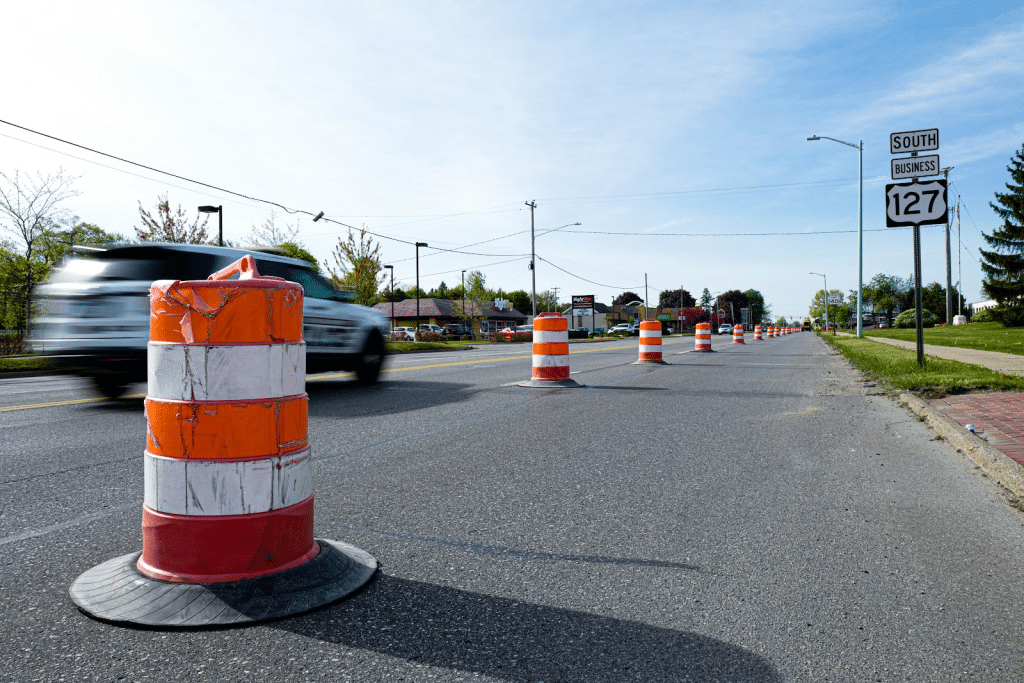
Construction cones and a bit of commuting confusion have greeted drivers along Mission Street in Mt. Pleasant during recent days.
While the current construction project is a Michigan Department of Transportation (MDOT) $1.3M resurfacing effort through Aug. 14, it’s laying the groundwork for a larger project coming to Mission Street—including lane modifications that will accommodate a future shared-use pathway.
It’s the first viable step in the City of Mt. Pleasant’s Mission Street Improvement Plan. This plan has been in discussion since 2019, with the goal of making Mission Street safer and more accessible. Plus, improve commercial vacancies and overall beautification of the busy corridor.
We spoke with Manuela Powidayko, the City of Mt. Pleasant’s director of planning and community development to learn more.

Epicenter Mt. Pleasant: The Mission Street Improvement Plan, led by the City of Mt. Pleasant, addresses longstanding challenges along the three-mile Mission Street Corridor—ultimately providing solutions for safety, commercial vacancies, and other roadway improvements and connections, correct?
Manuela Powidayko: Yes. Discussions about the future of Mission Street started back in 2019 during the Mt. Pleasant 2050 Master Plan public engagement process. At the time, Mission was identified as an east/west barrier in Mt. Pleasant, posing safety concerns for both traveling north/south and crossing the corridor.
The goal was then established: “To increase walkability and attractiveness for pedestrians and visitors.”
However, this was prior to the pandemic and at the time, the goal was to create a “downtown feel” for Mission Street, which led to specific design goals that included adding on-street parking along the corridor, implement multiple roundabouts in several intersections, and convert the corridor into a boulevard.
The Master Plan tasked the Planning Commission and the Mission/Pickard DDA to lead the Mission Street project and partner with the Michigan Department of Transportation (MDOT), Central Michigan University (CMU) and business owners to “reimagine Mission Street as a vital business district and front door to the community and university.”
Since the Plan adoption in 2020, City staff and MDOT met quarterly but no major progress was made due to lack of funding and because the conceptual design previously adopted, required a wider right-of-way that the current conditions do not support.
As such, in 2024, the Planning Commission and the DDA met to review new traffic data and a narrow boulevard feasibility analysis by MDOT, which led to the decision of hiring an engineering/planning consultant and conveying a Steering Committee to refine the corridor’s design improvements. That is how the Mission Street Improvement Plan, funded by the Michigan Economic Development Corporation and the Mission/Pickard DDA, was developed, which also included a public outreach process.
A major shift in the corridor’s vision was to celebrate how busy the corridor is as it brings business to Mt. Pleasant, with the goal to not decrease vehicular counts, but to simultaneously improve safety and the visual appeal of the corridor. The Plan created, therefore, a list of feasible design treatments that can be built over time to address traffic congestion, pedestrian, and bicycle safety, universal accessibility, and business access.
Epicenter: With your recent $1.47M grant financial assistance from MDOT, tell us more about the improvements we can expect on the south half of Mission Street, especially when it comes to the shared-use pathway?
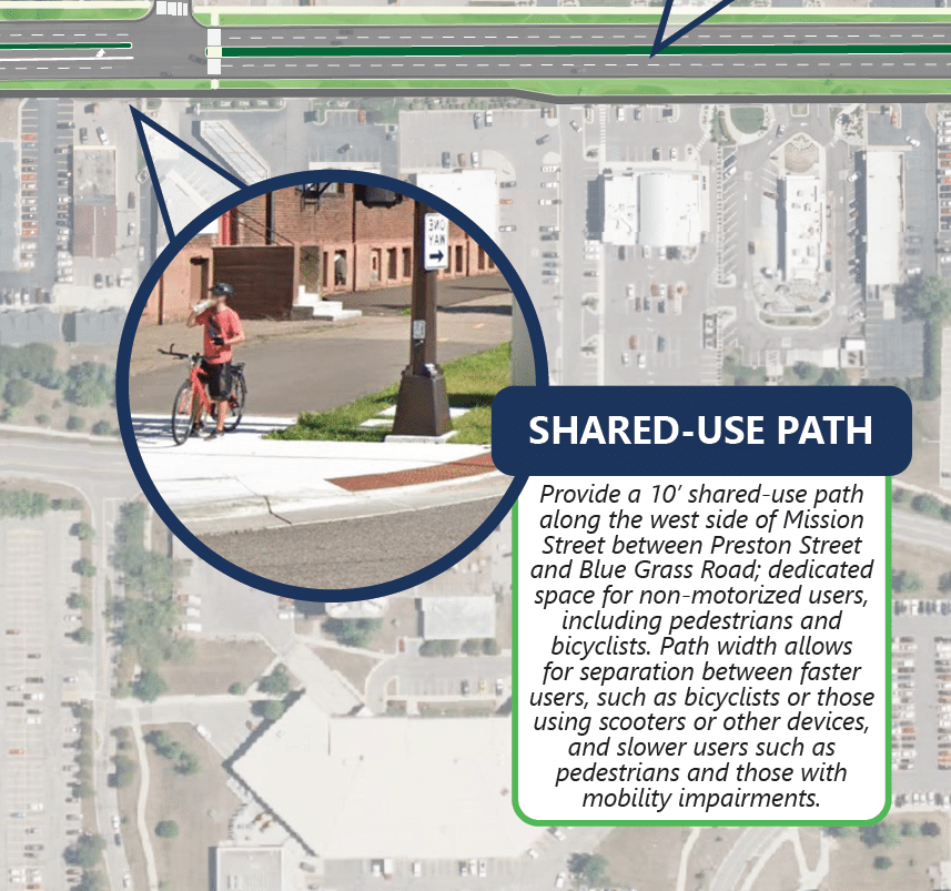
Powidayko: The City of Mt. Pleasant is the recipient of federal Transportation Alternatives Program (TAP) funds to construct a shared use pathway for 1.5 miles beginning at the intersection of Mission Street/Business Route US-127 and Bluegrass Road, traveling north on the west side of Mission Street to Preston Road, traveling west on the south side of Preston Road to East Campus Drive, then traveling north on East Campus Drive to Bellows Street.
The project includes construction of 10-12 foot wide concrete pathway, modification of the right turn lane on southbound Mission Street at Broomfield Road, modification of the right turn lane on eastbound Preston Street at Mission Street, new crosswalk installation on Bellows Street, improve unsignalized crossings of city streets, wayfinding signage, benches, trash receptacles, bike racks, and shade trees.
This project will address barriers and conflicts to nonmotorized traffic along the commercial corridor on Mission Street, and connect people to streets with lower speeds of traffic and an existing nonmotorized network through residential areas, the Central Michigan University campus, the Smart Zone, downtown businesses, regional trails, bike routes, and indirectly to transit stops.
The project will support economic development by providing access to shopping, add to the City’s recreation trail opportunities for visitors, and improve enrollment rates at CMU by enhancing mobility around campus.
The total project cost is $2,268,830 including $1,474,740 in TAP funds administered by MDOT and $794,090 in matching funds from the City of Mt. Pleasant.
Epicenter: How will these changes improve the corridor for both drivers and nonmotorized users of Mission Street?
Powidayko: The existing sidewalk along Mission Street provides an option for people outside of a vehicle to traverse the street today. However, its narrow width, proximity to the roadway, and frequent curb-cut make the sidewalk difficult to use and make the experience as a pedestrian or bicyclist unsafe and unpleasant.
Between Blue Grass Road and Preston Street, the wide right-of-way (ROW) and relatively few curb cuts provide opportunities to introduce non-motorized facilities that are appropriately buffered from vehicular traffic. North of Preston Street, as ROW narrows and driveway spacing decreases, bicyclists should be directed with signage and pavement markings to Kinney Avenue, considered a neighborhood greenway.
The shared-use pathway is a better alternative to bicycle facilities that are often placed on the road, as they were not recommended in the Mission Street Improvement Plan due to the high vehicle speeds and volumes. Although utilization of Mission Street by ‘vehicular’ cyclists, who ride with vehicle traffic, may still occur, provision of a robust separated facility will best facilitate safe and comfortable riding.
Epicenter: When will the shared-use pathway construction take place?
Powidayko: The target is to start construction in Spring 2027, which will likely continue until the end of Fall.
Epicenter: Now this shared-use path is one of many proposed improvements the City has to provide a better Mission Street. Can you tell us more about them?
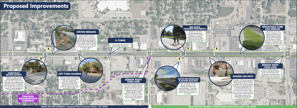
Powidayko: Pages 10 and 11 of the Mission Street In Motion: Summary Report contain a list of design improvements that address the Master Plan and the Mission Street Plan goals and objectives. These became the corridor’s toolkit for improvements that can happen over time as funding becomes available and opportunities arise.
It is important to note that the Plan includes a conceptual design for the corridor to illustrate what is possible. As improvements can be funded, detailed engineering analysis is needed to verify and fine-tune the details of such improvements.
Epicenter: What are the current timelines for each of these improvements?
Powidayko: The only improvement that has been funded at this time is the shared-use pathway. It may take years or decades to complete the full scope of improvements, but having an improvement plan already developed increases the City’s and MDOT’s chances of identifying funding sources and being selected in often highly competitive processes. MDOT’s Mt. Pleasant Transportation Service Center (TSC) was part of the Steering Committee during Plan development and are great supporters of our initiatives.
Epicenter: One of the proposed changes is to remove the right-turn lane going south on Mission, turning onto Broomfield, including a testing period where residents may experience a temporary curb. Since that’s a high-traffic intersection in town, what do we need to know about this?
Powidayko: MDOT is currently resurfacing US-127 Business Route (BR) (South Mission Street) this year and will conduct the resurfacing of North Mission Street next year.
After discussions with the Mission/Pickard DDA, staff and MDOT were directed to not completely remove the right-turn lane as part of the shared-use path but that its design should meet current MDOT standards, which calls for an approximate 300 feet lane length reduction.
As such, MDOT will be restripping the lane this year during the resurface project. The proposed right turn lane is 250’, with a 130’ taper, for a total length of 380’ (right turn lane plus taper). The existing right turn lane plus taper is approximately 680’.
Another important change is the removal of an extra four-foot buffer zone that exists due to current curb-cut distances. That removal will increase the distance between the future shared-use path and the curb, which will improve comfort for pedestrians and bikers utilizing the pathway. That change will also reduce the north crosswalk at the Mission and Broomfield intersection by four feet, also improving the crossing experience and pedestrian/cyclist safety.
Epicenter: What else do our readers need to know?
Powidayko: The shared-use path project implementation is a great example of why proactive planning matters, as having a formal framework significantly increases the City’s and MDOT’s chances of securing critical funding.
By establishing clear community-backed data and corridor concepts, this localized planning lays the structural groundwork necessary to transform Mission Street into a safe, universally accessible, and non-motorized friendly thoroughfare.
This proactive coordination aligns directly with the City’s Master Plan 2050 goals, continuous zoning updates, cross-access business requirements, and strategic infrastructure investments into an actionable blueprint for a safer, more connected multi-modal grid.
Author

Related Articles

Inside the decision-making behind MPPS snow days
When winter weather threatens Isabella County, Mt. Pleasant Public Schools begins evaluating conditions long before families wake up. From National Weather Service briefings to early-morning road checks, district leaders weigh multiple factors before deciding whether to cancel or delay classes—all with student safety as the top priority.

Partner Partner Content On Board for Autism: Airport simulation helps autistic kids take flight
To help autistic people and their families manage these challenges, Autism Alliance of Michigan (AAoM), Delta Airlines, and the Detroit Metropolitan Airport partner to host On Board for Autism events that prepare them to successfully take a flight.

Understanding Isabella County’s millage renewal vote
Isabella County residents face a pivotal decision on August 6, as they vote on the renewal of three essential millages. With no increases in property tax rates since 1978, these millages support a wide array of services from public safety to health and community development. Understand the significant impact of the vote with the facts.


